 |
 |
 |
|
Funded
in part by  |
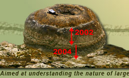
2004 Aceh/Andaman earthquake |
|
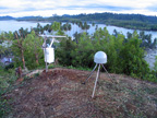
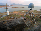
Sumatran GPS Array data To scientists and others who use the SuGAr data, please note: The Sumatran GPS Array is being designed, constructed and operated by members of the Tectonics Observatory at Caltech and the Indonesian Institute of Sciences (LIPI). The SuGAr data are processed and archived at SOPAC (Scripps Orbit and Permanent Array Center). Funding for the SuGAr comes to the Tectonics Observatory exclusively from the Gordon and Betty Moore Foundation. The Observatory is pleased to make the SuGAr data available to anyone who wishes to use them. However, if you use these data in your published work, the Tectonics Observatory requests that you acknowledge the scientists and technicians of the Observatory, LIPI and SOPAC, who are establishing, maintaining and operating the array. Access the rinex data files from SOPAC. This page will eventually also contain ArcGIS data used to construct our map of the plate boundary and site maps and basic data associated with our studies of the coral microatolls. |
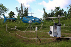

Western Sumatra Seismic Network Six short-period seismic stations were installed in Sumatra in May 2005 in order to better determine the locations of aftershocks of the Decmeber 26, 2004 and March 28, 2005 great earthquakes in the Sunda Trench. Each site, co-located with GPS stations of the SuGAr array, has an L4 1-Hz verticle seismometer recorded by a Nanometrics Taurus 24-bit logger. The data are continuously recorded on site and are retrieved every 3 to 5 months. Preliminary analysis of the data is done using
the software program SEISAN, and initial results indicate a far
greater level of seismicity in the region than reported by the
NEIC and other agencies, especially in the area around Nyang
Nyang. |