Updated Result
04/12/26 (Mw 9.15) , Sumatra-Andaman Earthquake
Mohamed Chlieh, Caltech
Data and References
This is a geodetic model of of the 2004 Sumatra-Andaman Earthquake. We have used near-field GPS data (Subarya et al. 2006) and far field GPS data (Vigny et al.> 2005. In addition, near field measurements of coral uplift and subsidence, and uplifts from satellite images (Meltzner et al., 2006) were utilized. See Chlieh et al. 2007 for the details of the study.Map view of the slip distribution
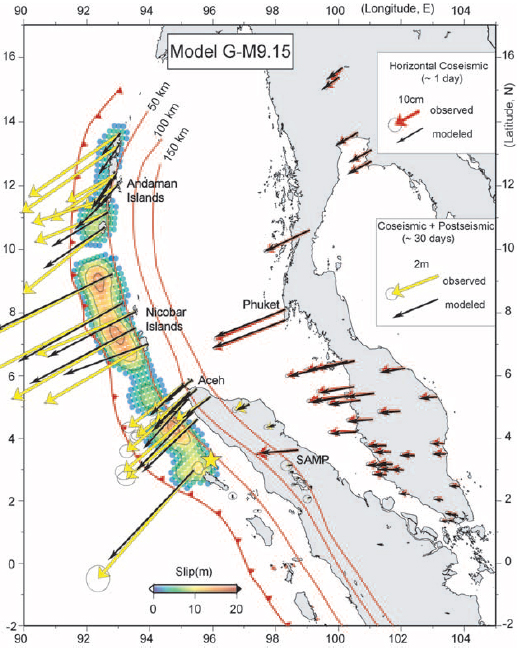
Figure 1: Slip distribution and predicted GPS displacements (black arrows) for the perferred coseismicmodel. .
Comments:
Download
(Slip Distribution)| SUBFAULT FORMAT |
References
Chlieh, M., Jean-Philippe Avouac, Vala Hjorleifsdottir, Teh-Ru Alex Song, Chen Ji,Kerry Sieh, Anthony Sladen, Helene Hebert, Linette Prawirodirdjo, Yehuda Bock, and John Galetzka "Coseismic Slip and Afterslip of the Great Mw 9.15 Sumatra-Andaman Earthquake of 2004, Bulletin of the Seismological Society of America, Vol. 97, No. 1A, pp. S152S173, 2007.
Ji, C., D.J. Wald, and D.V. Helmberger, Source description of the 1999 Hector
Mine, California earthquake; Part I: Wavelet domain inversion theory and resolution
analysis,
Bassin, C., Laske, G. and Masters, G., The Current Limits of Resolution for
d Surface Wave Tomography in North America, EOS Trans AGU, 81, F897, 2000.
Subarya, C., M. Chlieh, L. Prawirodirdjo, J. P. Avouac, Y. Bock, K. Sieh, A. J. Meltzner, D. H. Natawidjaja, and R. McCaffrey (2006). Plate boundary deformation associated with the great Sumatra-Andamanearthquake, Nature 440, 4651.
Vigny, C., W. J. F. Simons, S. Abu, R. Bamphenyu, C. Satirapod, N. Choosakul, C. Subarya, A. Socquet, K. Omar, H. Z. Abidin, and B. A. C. Ambrosius (2005). Insight into the 2004 Sumatra-Andaman earthquake from GPS measurements in southeast Asia, Nature 436, 201-206.
GCMT project: http://www.globalcmt.org/
USGS National Earthquake Information Center: http://neic.usgs.gov
Global Seismographic Network (GSN) is a cooperative scientific facility operated jointly by the Incorporated Research Institutions for Seismology (IRIS), the United States Geological Survey (USGS), and the National Science Foundation (NSF).
‹Back to Slip Maps for Recent Large Earthquakes home page